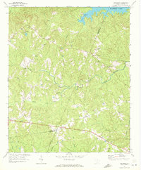
1971 Map of Longtown
USGS Topo · Published 1972About this map
Longtown and Warren Crossroads anchor this rural landscape in the early 1970s, where the rolling uplands of Fairfield and Kershaw Counties meet the irregular northern shoreline of Wateree Lake. The map reveals a deeply established community pattern defined by numerous rural congregations and family burial grounds, including Antioch Ch, White Oak Ch, and the Mt Olive Cem. The drainage network is particularly dense here, with Sawneys Creek, Thorntree Creek, and Bell Branch carving the terrain into a complex system of ridges and draws. This document captures the area before modern residential expansion around the lakefront, showing Colonel Creek Landing and Camp Longridge as primary points of activity along the water's edge, while the interior remains a mosaic of timberland and small clearings.
Find a feature on this map
32 named features on this map. Tap any name to fly to it.
Don’t see what you’re looking for? This feature index may not catch every label — zoom into the map to look around manually.
Map Details
Editions of this 1971 Longtown Map
This is the sole edition of this map. No revisions or reprints were ever made.
Other maps of this area

1935 · Camden
USGS Topo · 1:48,000

1935 · Killian
USGS Topo · 1:48,000

1937 · Killian
USGS Topo · 1:62,500

1938 · Camden
USGS Topo · 1:62,500

1938 · Hagood
USGS Topo · 1:62,500

1941 · Spartanburg
USGS Topo · 1:250,000

1942 · Camden
USGS Topo · 1:125,000

1953 · Blythewood
USGS Topo · 1:24,000

1953 · Lugoff
USGS Topo · 1:24,000

1953 · Blaney
USGS Topo · 1:24,000