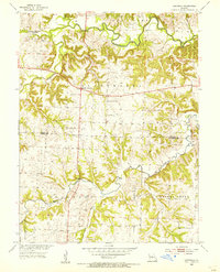
1953 Map of Longwood
USGS Topo · Published 1955About this map
The Blackwater River and Salt Fork dominate the northern landscape of this mid-century survey, defining the irregular boundaries between Liberty and Blackwater townships. This area of Missouri, straddling the line between Saline and Pettis Counties, shows a rural community structure centered around small hubs like Marshall Junction and the namesake settlement of Longwood. The map provides significant detail for family historians, noting several burial grounds including Witcher Cem, Bethlehem Cem, and Cunningham Cem. Education is represented by the Prairie Lawn Sch and the already noted Pleasant Valley Sch (Abandoned), suggesting a shift in rural school districts by the early 1950s. The network of creeks, such as Heath Creek and Finney Creek, reveals a heavily dissected terrain where agriculture followed the contours of the numerous small branches.
Find a feature on this map
23 named features on this map. Tap any name to fly to it.
Don’t see what you’re looking for? This feature index may not catch every label — zoom into the map to look around manually.
Map Details
Editions of this 1953 Longwood Map
2 editions found
Other maps of this area

1887 · Sedalia
USGS Topo · 1:125,000

1890 · Marshall
USGS Topo · 1:125,000

1892 · Marshall
USGS Topo · 1:125,000

1894 · Sedalia
USGS Topo · 1:125,000

1901 · Marshall
USGS Topo · 1:125,000

1939 · Sweet Springs
USGS Topo · 1:62,500

1940 · Sweet Springs
USGS Topo · 1:62,500

1940 · Marshall
USGS Topo · 1:62,500

1941 · Sweet Springs
USGS Topo · 1:62,500

1944 · Marshall
USGS Topo · 1:62,500