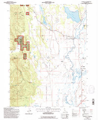
1993 Map of Lookout
USGS Topo · Published 1996About this map
The small settlement of Lookout sits at the edge of Big Valley in this northern California landscape, defined by a complex network of water management features and timbered uplands. Evidence of late 20th-century irrigation and flood control is visible through numerous structures like Fulcher Dam, Geng Dam, and various Check Dams, which regulate the flow of Valley Creek and the Pit River. The eastern half of the map is dominated by the Ash Creek State Wildlife Area and the marshy expanses of Big Swamp, while the western terrain rises into the Modoc National Forest. Local infrastructure is anchored by the Lookout Siding railroad point and Southard Field, serving a region where ranching and natural resource management intersect. From the high point at Summit down through the drainage of Canyon Creek, the map traces a transition from managed forest to the fertile, canal-crossed valley floor.
Find a feature on this map
52 named features on this map. Tap any name to fly to it.
Don’t see what you’re looking for? This feature index may not catch every label — zoom into the map to look around manually.
Map Details
Editions of this 1993 Lookout Map
This is the sole edition of this map. No revisions or reprints were ever made.
Other maps of this area

1886 · Modoc Lava Bed
USGS Topo · 1:250,000

1892 · Modoc Lava-Bed
USGS Topo · 1:250,000

1954 · Alturas
USGS Topo · 1:250,000

1958 · Alturas
USGS Topo · 1:250,000

1961 · Bieber
USGS Topo · 1:62,500

1961 · Fall River Mills
USGS Topo · 1:62,500

1962 · Alturas
USGS Topo · 1:250,000

1962 · Crank Mountain
USGS Topo · 1:62,500

1962 · White Horse
USGS Topo · 1:62,500

1965 · Alturas
USGS Topo · 1:250,000