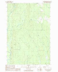
1989 Map of Lookout Mountain
USGS Topo · Published 1989About this map
Lookout Mountain rises above a landscape of dense water networks in this northern Penobscot County region, surveyed during the mid-1980s. The terrain is defined by the convergence of the Seboeis River and the Penobscot River, with the Wassataquoik Str entering from the west. This area, largely comprised of unorganized territories such as T 3 R 7 Wels and T 4 R 7 Wels, shows the subtle footprint of forest-based industry and travel through sites like Lunksoos Camp and Hunt Farm. The mapping includes the Monument Line, a significant surveying boundary that bisects the quadrangle between the townships of Patten and Stacyville. Smaller water bodies like Potter Pond and the branching reaches of Swift Brook illustrate the intricate drainage patterns of the Maine woods before modern development altered these remote drainages.
Find a feature on this map
22 named features on this map. Tap any name to fly to it.
Don’t see what you’re looking for? This feature index may not catch every label — zoom into the map to look around manually.
Map Details
Editions of this 1989 Lookout Mountain Map
This is the sole edition of this map. No revisions or reprints were ever made.
Other maps of this area

1940 · Island Falls
USGS Topo · 1:62,500

1940 · Sherman
USGS Topo · 1:62,500

1942 · Island Falls
USGS Topo · 1:62,500

1942 · Sherman
USGS Topo · 1:62,500

1953 · Stacyville
USGS Topo · 1:62,500

1954 · Shin Pond
USGS Topo · 1:62,500

1954 · Presque Isle
USGS Topo · 1:250,000

1954 · Millinocket
USGS Topo · 1:250,000

1958 · Presque Isle
USGS Topo · 1:250,000

1958 · Millinocket
USGS Topo · 1:250,000