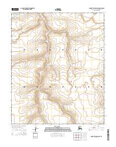
2014 Map of Lookout Ridge D-5 SW
USGS Topo · Published 2014About this map
Township and range lines define the structure of this remote North Slope landscape, where the public land survey system organizes a vast expanse of arctic terrain. The map area is primarily composed of the junction between T6n R28w and T6n R27w in the north, meeting T5n R28w and T5n R27w to the south. In this sparsely labeled region of Alaska, the topographic contours reveal the subtle rise and fall of the Lookout Ridge system, providing a rare high-resolution look at the drainage patterns and elevation changes of the high arctic before modern climate shifts further alter the permafrost-driven geography.
Find a feature on this map
4 named features on this map. Tap any name to fly to it.
Don’t see what you’re looking for? This feature index may not catch every label — zoom into the map to look around manually.
Map Details
Editions of this 2014 Lookout Ridge D-5 SW Map
This is the sole edition of this map. No revisions or reprints were ever made.
Other maps of this area

1951 · Utukok River
USGS Topo · 1:250,000

1951 · Lookout Ridge
USGS Topo · 1:250,000

1956 · Lookout Ridge
USGS Topo · 1:250,000

1956 · Utukok River
USGS Topo · 1:250,000

1965 · Utukok River
USGS Topo · 1:250,000
1984 · Lookout Ridge D-5
USGS Topo · 1:63,360
1984 · Lookout Ridge C-5
USGS Topo · 1:63,360
1984 · Utukok River D-1
USGS Topo · 1:63,360
1984 · Utukok River C-1
USGS Topo · 1:63,360
2014 · Utukok River C-1 NE
USGS Topo · 1:25,000