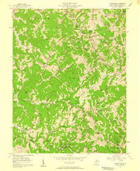
1957 Map of Looneyville
USGS Topo · Published 1959About this map
Looneyville and the surrounding hill country of Roane County are defined by a complex network of gas wells and winding creek valleys in the mid-1950s. The landscape is dotted with numerous small family-named cemeteries such as Watson Cem and Looney Cem, alongside rural social centers like Epling Chapel and Banner Sch. This survey highlights a rural economy shifting between traditional homesteading and energy extraction, as evidenced by the dense concentration of oil and gas wells. Remote travel is facilitated by the Stringtown Jeep Trail and the Jeep Trail near Speed, connecting isolated settlements like Clover and Lefthand. The topographical detail captures the region before more modern infrastructure, preserving the locations of vanished schools such as Stalnaker Sch and landmarks like Buck Knob.
Find a feature on this map
76 named features on this map. Tap any name to fly to it.
Don’t see what you’re looking for? This feature index may not catch every label — zoom into the map to look around manually.
Map Details
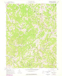
Editions of this 1957 Looneyville Map
2 editions found
Other maps of this area

1906 · Otter
USGS Topo · 1:62,500

1906 · Walton
USGS Topo · 1:62,500

1907 · Otter
USGS Topo · 1:62,500

1907 · Arnoldsburg
USGS Topo · 1:62,500

1907 · Spencer
USGS Topo · 1:62,500

1907 · Walton
USGS Topo · 1:62,500

1925 · Arnoldsburg
USGS Topo · 1:62,500

1927 · Arnoldsburg
USGS Topo · 1:62,500

1928 · Spencer
USGS Topo · 1:62,500

1954 · Charleston
USGS Topo · 1:250,000