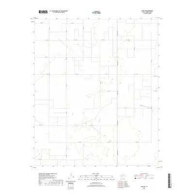
2019 Map of Loop SW
USGS Topo · Published 2019About this map
McKenzie Draw carves a subtle path through the high plains of Gaines County, defining the hydrologic character of this West Texas landscape. The region is predominantly organized by a rigorous grid of section lines and county roads, reflecting the systematic land division typical of the Llano Estacado. Significant transit corridors like Ranch Rd 303 and FM Rd 1066 provide the primary infrastructure through these wide-open spaces, connecting the scattered agricultural and ranching interests that dominate the area. The map's contour lines illustrate the gentle depressions and rises that characterize the topography, where seasonal drainage features like McKenzie Draw are the most prominent natural landmarks. Local movement is facilitated by a dense network of numbered routes including Co RD 122, Co RD 114, and Co RD 108, which trace the property boundaries of this expansive rural territory.
Find a feature on this map
19 named features on this map. Tap any name to fly to it.
Don’t see what you’re looking for? This feature index may not catch every label — zoom into the map to look around manually.
Map Details
Editions of this 2019 Loop SW Map
This is the sole edition of this map. No revisions or reprints were ever made.
Other maps of this area

1954 · Hobbs
USGS Topo · 1:250,000

1958 · Hobbs
USGS Topo · 1:250,000

1969 · Loop
USGS Topo · 1:24,000

1969 · Ashmore
USGS Topo · 1:24,000

1970 · Seminole NE
USGS Topo · 1:24,000

1970 · Seagraves SE
USGS Topo · 1:24,000

1970 · McKenzie Lake NW
USGS Topo · 1:24,000

1970 · Seagraves
USGS Topo · 1:24,000
1970 · Loop SW
USGS Topo · 1:24,000

1970 · McKenzie Lake
USGS Topo · 1:24,000