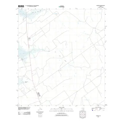
2010 Map of Lopeno
USGS Topo · Published 2010About this map
The Falcon Reservoir defines the western edge of this South Texas landscape, where the Rio Grande's waters meet the arid brushland of Zapata County. The settlement of Lopeño sits along the highway, while further south, the residential clusters of New Falcon and New Falcon Colonia reflect more recent development patterns in this border region. The area is characterized by an extensive network of ephemeral drainages that carve through the terrain toward the reservoir, including the Arroyo del Tigre Grande, Arroyo del Tigre Chiquita, and Arroyo Tinajas. Local industry is anchored by the Lopeno Gas Field, indicating the importance of energy extraction to the local economy. Traces of rural infrastructure appear through routes like Palmyra Rd and Los Lobos Rd, which connect scattered ranching and industrial sites across the scrubland.
Find a feature on this map
14 named features on this map. Tap any name to fly to it.
Don’t see what you’re looking for? This feature index may not catch every label — zoom into the map to look around manually.
Map Details
Editions of this 2010 Lopeno Map
This is the sole edition of this map. No revisions or reprints were ever made.
Other maps of this area

1938 · Falcon
USGS Topo · 1:62,500

1938 · El Sauz
USGS Topo · 1:62,500

1938 · Cuevitas
USGS Topo · 1:62,500

1949 · Mc Allen
USGS Topo · 1:250,000

1954 · McAllen
USGS Topo · 1:250,000

1956 · Arroyo Clareno
USGS Topo · 1:62,500

1957 · Mc Allen
USGS Topo · 1:250,000

1962 · McAllen
USGS Topo · 1:250,000

1965 · Salineno
USGS Topo · 1:24,000
1965 · Falcon Village
USGS Topo · 1:24,000