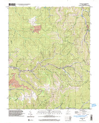
1996 Map of Lorado
USGS Topo · Published 2003About this map
Buffalo Creek winds through a landscape defined by deep-hollow coal mining and gas extraction at the end of the 20th century. This Logan County corridor is densely marked with settlements like Lorado, Craneco, and Lundale, which developed along the narrow creek bottoms. The map documents the heavy industrial footprint of the era, including a massive Strip Mine in the Washington district and a Mine Dump near Pardee.
Find a feature on this map
57 named features on this map. Tap any name to fly to it.
Don’t see what you’re looking for? This feature index may not catch every label — zoom into the map to look around manually.
Map Details
Editions of this 1996 Lorado Map
This is the sole edition of this map. No revisions or reprints were ever made.
Other maps of this area

1891 · Oceana
USGS Topo · 1:125,000

1893 · Oceana
USGS Topo · 1:125,000

1898 · Oceana
USGS Topo · 1:125,000

1909 · Gilbert
USGS Topo · 1:48,000

1910 · Pineville
USGS Topo · 1:48,000

1910 · Bald Knob
USGS Topo · 1:48,000

1912 · Bald Knob
USGS Topo · 1:62,500

1912 · Gilbert
USGS Topo · 1:62,500

1912 · Pineville
USGS Topo · 1:62,500

1913 · Logan
USGS Topo · 1:62,500