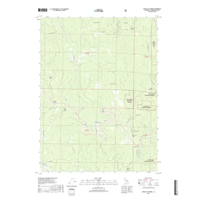
2018 Map of Lord-Ellis Summit
USGS Topo · Published 2018About this map
Green Point and Berry Summit are focal points for human activity in this high-elevation region of Humboldt County, where the terrain is dominated by a complex network of ridges and drainages. The Six Rivers National Forest covers much of the eastern and southern portions of the map, intersected by historic thoroughfares like Old Hwy 299 and Bair Rd. The landscape's hydrology is defined by the northward flow of Redwood Creek, which is fed by numerous tributaries including Lupton Creek and Sweathouse Creek. Local landmarks like Princess Rock and the aptly named Circle Point provide navigational markers across the varied topography. For those interested in regional heritage, the map preserves the names of early routes such as the Old Dolly Varden Rd and the Lacks Mountain Trail, which follow the contours of Beaver Ridge and Wiregrass Ridge.
Find a feature on this map
54 named features on this map. Tap any name to fly to it.
Don’t see what you’re looking for? This feature index may not catch every label — zoom into the map to look around manually.
Map Details
Editions of this 2018 Lord-Ellis Summit Map
This is the sole edition of this map. No revisions or reprints were ever made.
Other maps of this area

1915 · Big Bar and Vicinity
USGS Topo · 1:250,000

1922 · Korbel
USGS Topo · 1:62,500

1922 · China Flat
USGS Topo · 1:62,500

1925 · Hoopa
USGS Topo · 1:125,000

1945 · Coyote Peak
USGS Topo · 1:62,500

1945 · Blue Lake
USGS Topo · 1:62,500

1948 · Weed
USGS Topo · 1:250,000

1950 · Weed
USGS Topo · 1:250,000

1951 · Blue Lake
USGS Topo · 1:62,500

1952 · Willow Creek
USGS Topo · 1:62,500