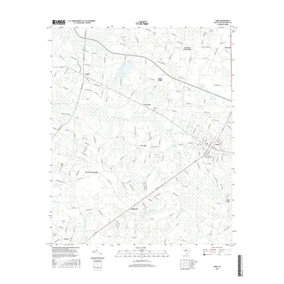
2017 Map of Loris
USGS Topo · Published 2017About this map
Loris serves as the primary hub of this corner of Horry County, where the street grid of the town center transitions into a landscape dominated by expansive wetlands and family-named rural settlements. The drainage patterns of the coastal plain are clearly defined by the branching waters of Pleasant Meadow Swamp and Mitchell Swamp, which dictate the placement of local roads and historical crossroads. Genealogists will find a high density of small family and community burial grounds, such as Harrelson Cem and Patterson Cem, reflecting the deep-rooted settlement patterns of the area. Distinctive landscape features like the Devils Cotton Patch and numerous bays including Fox Bay and Piney Bay illustrate the unique geological depressions characteristic of the region. From the crossroads at Finklea to the clustered homesteads of Princeville and Live Oak, the map provides a precise record of how agriculture and topography have shaped this South Carolina interior.
Find a feature on this map
192 named features on this map. Tap any name to fly to it.
Don’t see what you’re looking for? This feature index may not catch every label — zoom into the map to look around manually.
Map Details
Editions of this 2017 Loris Map
This is the sole edition of this map. No revisions or reprints were ever made.
Other maps of this area

1937 · Nixonville
USGS Topo · 1:48,000

1942 · Nixonville
USGS Topo · 1:62,500

1943 · Adrian
USGS Topo · 1:24,000

1944 · Adrian
USGS Topo · 1:31,680

1948 · Bayboro
USGS Topo · 1:24,000

1949 · Bayboro
USGS Topo · 1:24,000

1949 · Duford
USGS Topo · 1:24,000

1949 · Georgetown
USGS Topo · 1:250,000

1953 · Florence
USGS Topo · 1:250,000

1954 · Florence
USGS Topo · 1:250,000