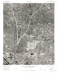
1974 Map of Los Alamitos
USGS Topo · Published 1977About this map
Los Alamitos and portions of Garden Grove appear in exceptional detail in this 1974 aerial orthophotograph, capturing the high-density suburban landscape of northern Orange County. The grid-like residential developments and intricate highway systems dominate the terrain, reflecting the rapid growth phase of the mid-1970s. This imagery offers a clear view of the Orange County Board of Supervisors jurisdiction, where industrial complexes, expansive airfields, and commercial centers are interspersed among residential blocks. The orthophoto format provides a literal bird's-eye view of land use, from the precise layout of neighborhood streets to the specialized infrastructure of regional transportation and aviation during this era of California's coastal expansion.
Find a feature on this map
3 named features on this map. Tap any name to fly to it.
Don’t see what you’re looking for? This feature index may not catch every label — zoom into the map to look around manually.
Map Details
Editions of this 1974 Los Alamitos Map
This is the sole edition of this map. No revisions or reprints were ever made.
Other maps of this area

1896 · Santa Ana
USGS Topo · 1:62,500

1896 · Anaheim
USGS Topo · 1:62,500

1896 · Las Bolsas
USGS Topo · 1:62,500

1896 · Downey
USGS Topo · 1:62,500

1898 · Anaheim
USGS Topo · 1:62,500

1899 · Downey
USGS Topo · 1:62,500

1901 · Southern California Sheet No. 1
USGS Topo · 1:250,000

1901 · Santa Ana
USGS Topo · 1:62,500

1901 · Anaheim
USGS Topo · 1:62,500

1902 · Downey
USGS Topo · 1:62,500