1919 Map of Los Gatos
USGS Topo · Published 1942About this map
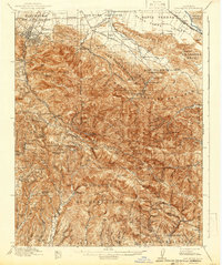
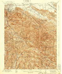
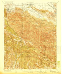
Los Capitancillos and the Pueblo Lands of San Jose dominate this 1915–1916 survey, which highlights the industrial and recreational character of the South Bay before mid-century suburbanization. The map provides an intricate look at the mining history centered on New Almaden and Mine Hill, while the Southern Pacific railroad snakes through the foothills past New Almaden Sta and Los Gatos.
Find a feature on this map
115 named features on this map. Tap any name to fly to it.
Don’t see what you’re looking for? This feature index may not catch every label — zoom into the map to look around manually.
Map Details
Editions of this 1919 Los Gatos Map
4 editions found

Other maps of this area

1889 · San Jose
USGS Topo · 1:62,500

1897 · San Jose
USGS Topo · 1:62,500

1897 · Mt. Hamilton
USGS Topo · 1:62,500

1897 · Palo Alto
USGS Topo · 1:62,500

1899 · San Jose
USGS Topo · 1:62,500

1899 · Palo Alto
USGS Topo · 1:62,500

1902 · Santa Cruz
USGS Topo · 1:125,000

1912 · Capitola
USGS Topo · 1:62,500

1914 · Capitola
USGS Topo · 1:62,500

1915 · San Juan Bautista
USGS Topo · 1:48,000