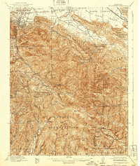
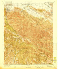
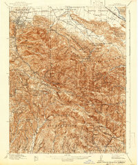
1919 Map of New Almaden
USGS Topo · Published 1939About this map
Mine Hill and the mercury-mining district at New Almaden anchor this survey of the southern reaches of the Santa Clara County and Santa Cruz County line. The map captures a transition from the developing valley floor near Los Gatos and Rinconada into the high ridges of the Santa Cruz Mountains. Evidence of early 20th-century mountain life is scattered across the topography, from isolated mountain schools like Hacienda School and Summit School to the Southern Pacific rail line threading through the canyons. This era is characterized by a mix of heavy industry and early recreational retreats, seen in the proximity of resource extraction at the mines to leisure sites like Canyons Resort and the Oaks Sanitarium. The terrain is marked by significant peaks, including Mt Umunhum and the high point of Loma Prieta.
Find a feature on this map
108 named features on this map. Tap any name to fly to it.
Don’t see what you’re looking for? This feature index may not catch every label — zoom into the map to look around manually.
Map Details
Editions of this 1919 New Almaden Map
4 editions found

Other maps of this area

1889 · San Jose
USGS Topo · 1:62,500

1897 · San Jose
USGS Topo · 1:62,500

1897 · Mt. Hamilton
USGS Topo · 1:62,500

1897 · Palo Alto
USGS Topo · 1:62,500

1899 · San Jose
USGS Topo · 1:62,500

1899 · Palo Alto
USGS Topo · 1:62,500

1902 · Santa Cruz
USGS Topo · 1:125,000

1912 · Capitola
USGS Topo · 1:62,500

1914 · Capitola
USGS Topo · 1:62,500

1915 · San Juan Bautista
USGS Topo · 1:48,000