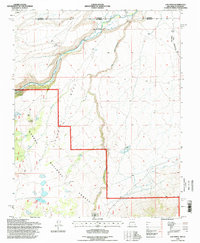
1995 Map of Los Pinos
USGS Topo · Published 1998About this map
Los Pinos and the winding Rio San Antonio define this borderland landscape where New Mexico meets Colorado. The settlement of Lava, marked by its distinctive Water Tower, sits along the narrow-gauge tracks of the Cumbres and Toltec Scenic Railroad, a surviving piece of 19th-century transit infrastructure that snakes through the high desert terrain. The area is heavily marked by livestock management and mineral exploration, featuring the Cisnero Mine No 1 and numerous isolated stock tanks such as Chino Peak Tank and Llano Tank.
Find a feature on this map
30 named features on this map. Tap any name to fly to it.
Don’t see what you’re looking for? This feature index may not catch every label — zoom into the map to look around manually.
Map Details
Editions of this 1995 Los Pinos Map
This is the sole edition of this map. No revisions or reprints were ever made.
Other maps of this area

1918 · Tusas
USGS Topo · 1:125,000

1922 · Conejos
USGS Topo · 1:125,000

1945 · Durango
USGS Topo · 1:250,000

1953 · Durango
USGS Topo · 1:250,000

1954 · Durango
USGS Topo · 1:250,000

1954 · Raton
USGS Topo · 1:250,000

1954 · Trinidad
USGS Topo · 1:250,000

1954 · Aztec
USGS Topo · 1:250,000

1955 · Trinidad
USGS Topo · 1:250,000

1958 · Raton
USGS Topo · 1:250,000