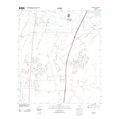
2013 Map of Losoya
USGS Topo · Published 2013About this map
The confluence of the Medina River and the San Antonio River anchors this South Texas landscape, where riparian corridors intersect with a developing network of rural roads and highways. The settlement of Losoya sits north of the riverbend, while Thelma is positioned along the western edge near Pleasanton Rd. The area is characterized by its agricultural roots and private aviation, evidenced by several landing strips including Triple R Airport, A W Ranch Airport, and Russell Paradise Airport.
Find a feature on this map
159 named features on this map. Tap any name to fly to it.
Don’t see what you’re looking for? This feature index may not catch every label — zoom into the map to look around manually.
Map Details
Editions of this 2013 Losoya Map
This is the sole edition of this map. No revisions or reprints were ever made.
Other maps of this area

1953 · Terrell Wells
USGS Topo · 1:24,000

1953 · Elmendorf
USGS Topo · 1:24,000

1953 · Southton
USGS Topo · 1:24,000

1954 · San Antonio
USGS Topo · 1:250,000

1957 · San Antonio
USGS Topo · 1:250,000

1958 · Losoya
USGS Topo · 1:24,000

1958 · Thelma
USGS Topo · 1:24,000

1958 · Saspamco
USGS Topo · 1:24,000
1964 · Saspamco SE
USGS Topo · 1:24,000

1964 · Leming
USGS Topo · 1:24,000