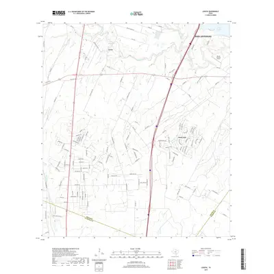
2019 Map of Losoya
USGS Topo · Published 2019About this map
The Medina River and San Antonio River converge south of San Antonio, defining a landscape where rural Texas settlements meet the edge of a growing metropolitan area. In this part of southern Bexar County, the community of Losoya sits near the confluence of Palo Blanco Cr and the river, reflecting the region's historic dependence on these watercourses. To the east, the waters of Victor Braunig Lake dominate the terrain, while the residential layout of Sandy Oaks shows the transition toward more organized suburban development. The map also captures the local transport network with roads like Pleasanton Rd and small local landmarks such as the Russell Paradise Airport. The boundary where Bexar, Atascosa, and Wilson counties meet is clearly delineated, showing how these political lines intersect with the natural drainage of Lucas Cr.
Find a feature on this map
124 named features on this map. Tap any name to fly to it.
Don’t see what you’re looking for? This feature index may not catch every label — zoom into the map to look around manually.
Map Details
Editions of this 2019 Losoya Map
This is the sole edition of this map. No revisions or reprints were ever made.
Other maps of this area

1953 · Terrell Wells
USGS Topo · 1:24,000

1953 · Elmendorf
USGS Topo · 1:24,000

1953 · Southton
USGS Topo · 1:24,000

1954 · San Antonio
USGS Topo · 1:250,000

1957 · San Antonio
USGS Topo · 1:250,000

1958 · Losoya
USGS Topo · 1:24,000

1958 · Thelma
USGS Topo · 1:24,000

1958 · Saspamco
USGS Topo · 1:24,000
1964 · Saspamco SE
USGS Topo · 1:24,000

1964 · Leming
USGS Topo · 1:24,000