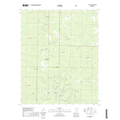
2020 Map of Lost Corner
USGS Topo · Published 2020About this map
Lost Corner sits within the high-relief terrain of the Ozark National Forest, marking the boundary between Pope and Van Buren counties. This mountain landscape is defined by its deep hollows and high ridges, which have historically shaped the settlement patterns of this part of Arkansas. Local families and history are tied to the specific topography of places like Victor Millsaps Hollow, Napier Hollow, and Campbell Hollow. The presence of the New Hope Cem provides a central point for genealogical interest, while numerous named peaks such as Snowlick Mtn, Armstead Mtn, and Stoebuck Mtn dominate the horizon. A network of Forest Service roads, including FR 1305 and FR 1331, provides access to the complex drainage systems of the W Prong Brushy Fork and the S Fork Little Red River, reflecting a region defined by its timber and watershed values.
Find a feature on this map
48 named features on this map. Tap any name to fly to it.
Don’t see what you’re looking for? This feature index may not catch every label — zoom into the map to look around manually.
Map Details
Editions of this 2020 Lost Corner Map
This is the sole edition of this map. No revisions or reprints were ever made.
Other maps of this area

1879 · Washington
USGS Topo · 1:62,500

1887 · Smyrna
USGS Topo · 1:62,500

1889 · Marshall #3
USGS Topo · 1:62,500

1892 · Marshall
USGS Topo · 1:125,000

1892 · Morrillton
USGS Topo · 1:125,000

1894 · Morrillton
USGS Topo · 1:125,000

1894 · Marshall
USGS Topo · 1:125,000

1901 · Marshall
USGS Topo · 1:125,000

1940 · Smyrna
USGS Topo · 1:62,500
1943 · Smyrna
USGS Topo · 1:62,500