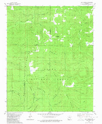
1980 Map of Lost Corner
USGS Topo · Published 1980About this map
Lost Corner sits along the dividing line of Pope and Van Buren counties, serving as a focal point for this section of the Ozark National Forest. The landscape is defined by the steep ridges of Oak Mountain and Snowlick Mountain, where the headwaters of the Illinois Bayou and the South Fork Little Red River begin their descent. Small, isolated settlements like Burnett, Victor, and Austin are scattered throughout the hollows, often centered around water sources or local landmarks such as New Hope Cem.
Find a feature on this map
37 named features on this map. Tap any name to fly to it.
Don’t see what you’re looking for? This feature index may not catch every label — zoom into the map to look around manually.
Map Details
Editions of this 1980 Lost Corner Map
This is the sole edition of this map. No revisions or reprints were ever made.
Other maps of this area

1879 · Washington
USGS Topo · 1:62,500

1887 · Smyrna
USGS Topo · 1:62,500

1889 · Marshall #3
USGS Topo · 1:62,500

1892 · Marshall
USGS Topo · 1:125,000

1892 · Morrillton
USGS Topo · 1:125,000

1894 · Morrillton
USGS Topo · 1:125,000

1894 · Marshall
USGS Topo · 1:125,000

1901 · Marshall
USGS Topo · 1:125,000

1940 · Smyrna
USGS Topo · 1:62,500
1943 · Smyrna
USGS Topo · 1:62,500