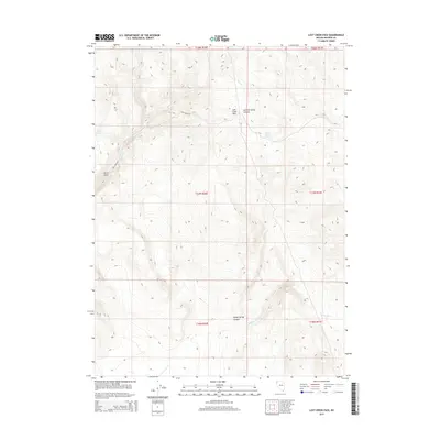
2015 Map of Lost Creek Pass
USGS Topo · Published 2015About this map
Lost Creek Pass serves as a central high-altitude crossing in this high desert landscape of Washoe County, where the terrain is defined by its seasonal hydrology and geological formations. The network of water sources, including Cherry Springs and Summit Spring, indicates the vital importance of reliable water in this arid environment for both livestock and travelers. The presence of Lost Creek Troughs further suggests managed range land, supporting a local economy tied to grazing. High-relief features like Devils Gate and the deep cuts of Summit Spring Canyon illustrate the erosive power of drainages such as Lost Cr and No Savvy Cr. This 2015 survey provides a modern snapshot of rural Washoe County land use, anchored by the winding Lost Creek Rd.
Find a feature on this map
17 named features on this map. Tap any name to fly to it.
Don’t see what you’re looking for? This feature index may not catch every label — zoom into the map to look around manually.
Map Details
Editions of this 2015 Lost Creek Pass Map
This is the sole edition of this map. No revisions or reprints were ever made.
Other maps of this area

1886 · Granite Range
USGS Topo · 1:250,000

1889 · Long Valley
USGS Topo · 1:250,000

1894 · Granite Range
USGS Topo · 1:250,000

1954 · Vya
USGS Topo · 1:250,000

1955 · Lovelock
USGS Topo · 1:250,000

1958 · Vya
USGS Topo · 1:250,000

1959 · Lovelock
USGS Topo · 1:250,000

1962 · Vya
USGS Topo · 1:250,000
1979 · Wall Canyon Reservoir
USGS Topo · 1:24,000
1979 · Chester Lyons Spring
USGS Topo · 1:24,000