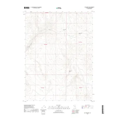
2018 Map of Lost Creek Pass
USGS Topo · Published 2018About this map
Lost Creek Pass serves as a central landmark in this high-elevation region of Washoe County, where the landscape is defined by drainage systems and essential water sources. The map traces the path of Lost Creek Rd as it maneuvers through the complex terrain toward Devils Gate. Water management and natural springs are vital to this arid environment, evidenced by labels for the Lost Creek Troughs, Summit Spring, and several perennial or intermittent drainages. Significant seasonal water flows are identified by Lost Cr in the north and No Savvy Cr in the south. The area's topography is further detailed through named features like Summit Spring Canyon and Sheep Spring Canyon, which dictate the movement of both water and traveler through this part of the Nevada backcountry.
Find a feature on this map
14 named features on this map. Tap any name to fly to it.
Don’t see what you’re looking for? This feature index may not catch every label — zoom into the map to look around manually.
Map Details
Editions of this 2018 Lost Creek Pass Map
This is the sole edition of this map. No revisions or reprints were ever made.
Other maps of this area

1886 · Granite Range
USGS Topo · 1:250,000

1889 · Long Valley
USGS Topo · 1:250,000

1894 · Granite Range
USGS Topo · 1:250,000

1954 · Vya
USGS Topo · 1:250,000

1955 · Lovelock
USGS Topo · 1:250,000

1958 · Vya
USGS Topo · 1:250,000

1959 · Lovelock
USGS Topo · 1:250,000

1962 · Vya
USGS Topo · 1:250,000
1979 · Wall Canyon Reservoir
USGS Topo · 1:24,000
1979 · Chester Lyons Spring
USGS Topo · 1:24,000