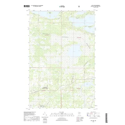
2019 Map of Lost Lake
USGS Topo · Published 2019About this map
Superior National Forest dominates this landscape in northeastern Minnesota, where the intricate shoreline of Vermilion Lake meets a dense network of waterways and timberland. The northern reach of the map is defined by the deep inlets of Frazer Bay, Daisy Bay, and Big Bay, separated by the prominent Birch Point. This area reflects a balance between conservation and recreation, evidenced by the extensive Arrowhead Snowmobile Trail winding through the interior toward Lost Lake and the southern Pike River Flowage. In the southwestern corner, the small settlement of Taconite sits near Pfeiffer Lake, hinting at the region's industrial ties to iron mining. The terrain is characterized by low-lying wetlands like the Lost Lake Swamp and numerous smaller water bodies such as Little Lost Lake and Pike River Lake, illustrating the complex glacial hydrography of St. Louis County.
Find a feature on this map
48 named features on this map. Tap any name to fly to it.
Don’t see what you’re looking for? This feature index may not catch every label — zoom into the map to look around manually.
Map Details
Editions of this 2019 Lost Lake Map
This is the sole edition of this map. No revisions or reprints were ever made.
Other maps of this area

1950 · Biwabik NW
USGS Topo · 1:24,000

1950 · Biwabik NE
USGS Topo · 1:24,000

1951 · Biwabik NE
USGS Topo · 1:24,000

1951 · Biwabik NW
USGS Topo · 1:24,000

1951 · Britt
USGS Topo · 1:24,000

1954 · Hibbing
USGS Topo · 1:250,000

1956 · Sioux Pine Island
USGS Topo · 1:24,000

1956 · Tower
USGS Topo · 1:24,000

1956 · Vermilion Dam
USGS Topo · 1:24,000

1956 · Lost Lake
USGS Topo · 1:24,000