
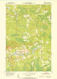
1951 Map of Biwabik NE
USGS Topo · Published 1951About this map
Vermilion Lake and the winding Pike River dominate this northern Minnesota landscape, where Finnish and Scandinavian settlement patterns are etched into the terrain of the Iron Range. The map reveals a rural society structured around small nodes like Wahlsten and Salo Corner, supported by community institutions such as School No 40 and Pike River Ch. This area, managed in part by the Iron Range Resources and Rehabilitation Commission, shows the intersection of industry and forest conservation. The presence of the Duluth Missabe and Iron Range railroad underscores the region's importance to the state's mining economy, even as large swaths remain protected within the Superior National Forest. Genealogists will find particular value in the identification of several burial grounds, including the Vermilion Lake Cem, the Old Vermilion Lake Cem, and the Embarrass Cem, which mark the early generations of local families.
Find a feature on this map
15 named features on this map. Tap any name to fly to it.
Don’t see what you’re looking for? This feature index may not catch every label — zoom into the map to look around manually.
Map Details
Editions of this 1951 Biwabik NE Map
2 editions found
Other maps of this area

1949 · Aurora
USGS Topo · 1:24,000

1949 · Embarrass
USGS Topo · 1:24,000

1950 · Embarrass
USGS Topo · 1:24,000

1950 · Aurora
USGS Topo · 1:24,000

1950 · Biwabik
USGS Topo · 1:24,000

1950 · Mc Kinley
USGS Topo · 1:24,000

1950 · Biwabik NW
USGS Topo · 1:24,000

1950 · Biwabik NE
USGS Topo · 1:24,000

1951 · Biwabik
USGS Topo · 1:24,000

1951 · Mc Kinley
USGS Topo · 1:24,000