1950 Map of Aurora
USGS Topo · Published 1950About this map
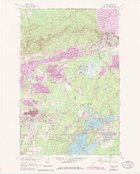
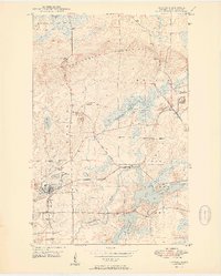
The Mesaba Iron Range dominates this mid-century landscape of northern Minnesota, revealing a complex industrial environment centered on the city of Aurora. Surveyed in the late 1940s, the map documents the heavy infrastructure of the iron industry, including the St James Pit, Miller Pit, and a large Ore Processing Plant. These operations are linked by an extensive rail network, primarily the Duluth Missabe and Iron Range, which includes an Abandoned RR segment near the town site. Beyond the industrial zones, the map captures the transition to the Superior National Forest, where water features like Colby Lake and Whitewater Lake break the terrain. Smaller settlements such as Old Mesaba, Mesaba, and Hinesdale dot the area, providing clear evidence of the historical labor and transport patterns of the Mesaba range during its post-war peak.
Find a feature on this map
31 named features on this map. Tap any name to fly to it.
Don’t see what you’re looking for? This feature index may not catch every label — zoom into the map to look around manually.
Map Details
Editions of this 1950 Aurora Map
2 editions found
Historical Maps of Hoyt Lakes Through Time
8 maps found