
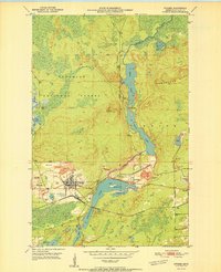
1951 Map of Biwabik
USGS Topo · Published 1951About this map
Industrial activity on the Mesabi Range dominates this 1951 survey, where the extraction of iron ore has reshaped the landscape between Biwabik and Aurora. Extensive mining operations are documented through labels for the Biwabik Mine, Ajax Mine, and Embarrass Mine, accompanied by a complex network of mine dumps, tailings basins, and gravel pits. The Duluth Missabe and Iron Range railroad serves as the primary artery for moving ore across the region, skirting the southern shores of Embarrass Lake. North of the industrial zones, the terrain shifts into the Superior National Forest and the Embarrass Mts, where Sabin Lake and Wynne Lake remain relatively undeveloped. The survey also captures the smaller settlements of Belgrade and Pineville, providing a detailed look at the interface between the iron industry and the surrounding wilderness.
Find a feature on this map
32 named features on this map. Tap any name to fly to it.
Don’t see what you’re looking for? This feature index may not catch every label — zoom into the map to look around manually.
Map Details
Editions of this 1951 Biwabik Map
2 editions found
Other maps of this area

1949 · Aurora
USGS Topo · 1:24,000

1949 · Embarrass
USGS Topo · 1:24,000

1950 · Embarrass
USGS Topo · 1:24,000

1950 · Aurora
USGS Topo · 1:24,000

1950 · Biwabik
USGS Topo · 1:24,000

1950 · Mc Kinley
USGS Topo · 1:24,000

1950 · Biwabik NW
USGS Topo · 1:24,000

1950 · Biwabik NE
USGS Topo · 1:24,000

1951 · Mc Kinley
USGS Topo · 1:24,000

1951 · Biwabik NE
USGS Topo · 1:24,000