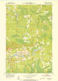
1951 Map of Biwabik NE
USGS Topo · Published 1951About this map
The Pike River and Embarrass River dominate this Iron Range landscape, carving through the township of Kugler toward the southern reaches of Vermilion Lake. The 1951 geography reveals a rural network of social and family centers, including the Pike River Ch, School No 40, and several community burial grounds such as the Embarrass Cem and Old Vermilion Lake Cem. Industry and transport are represented by the Duluth Missabe and Iron Range railroad and a local Gravel Pit. The map captures a moment before modern consolidation, where small crossroads like Salo Corner and the rail stop at Wahlsten served local homesteaders. To the south, the Forest Boundary marks the transition into the Superior National Forest, highlighting the area's mixed heritage of logging, mining, and frontier agriculture.
Find a feature on this map
16 named features on this map. Tap any name to fly to it.
Don’t see what you’re looking for? This feature index may not catch every label — zoom into the map to look around manually.
Map Details
Editions of this 1951 Biwabik NE Map
2 editions found

Other maps of this area

1949 · Aurora
USGS Topo · 1:24,000

1949 · Embarrass
USGS Topo · 1:24,000

1950 · Embarrass
USGS Topo · 1:24,000

1950 · Aurora
USGS Topo · 1:24,000

1950 · Biwabik
USGS Topo · 1:24,000

1950 · Mc Kinley
USGS Topo · 1:24,000

1950 · Biwabik NW
USGS Topo · 1:24,000

1950 · Biwabik NE
USGS Topo · 1:24,000

1951 · Biwabik
USGS Topo · 1:24,000

1951 · Mc Kinley
USGS Topo · 1:24,000