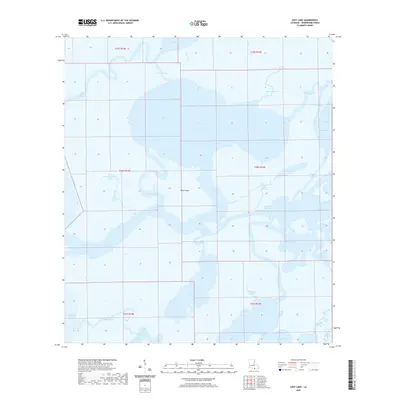
2020 Map of Lost Lake
USGS Topo · Published 2020About this map
Rice Island sits as a solitary named landmass amidst the intricate amphibious landscape of Terrebonne Parish, where the Gulf of Mexico meets the Louisiana coastal marshes. This 2020 survey documents a complex network of waterways, including the broad expanse of Lost Lake and the interconnected channels of The Narrows. The map reveals a hydraulic environment shaped by both natural evolution and human engineering, visible in features like the Crochet Canal and Plessala Cut, which facilitate navigation through the labyrinthine bayous. From the northern reaches of Carencro Lake to the southern shores of Bay Junop and Lake Mechant, the region is defined by its deep-water access and tidal bayous such as Bayou De Cade and Blue Hammock Bayou, illustrating the ever-shifting boundary between the mainland and the sea.
Find a feature on this map
39 named features on this map. Tap any name to fly to it.
Don’t see what you’re looking for? This feature index may not catch every label — zoom into the map to look around manually.
Map Details
Editions of this 2020 Lost Lake Map
This is the sole edition of this map. No revisions or reprints were ever made.
Other maps of this area

1894 · Bayou De Large
USGS Topo · 1:62,500

1932 · Lake Decade
USGS Topo · 1:62,500

1935 · Lake Mechant
USGS Topo · 1:31,680

1935 · Lake Penchant
USGS Topo · 1:31,680

1935 · Oyster Bayou
USGS Topo · 1:62,500

1940 · Bayou Du Large
USGS Topo · 1:62,500

1941 · Bayou Du Large
USGS Topo · 1:62,500

1944 · Bayou Du Large
USGS Topo · 1:62,500

1945 · New Orleans
USGS Topo · 1:250,000

1949 · Grand Bayou Du Large
USGS Topo · 1:31,680