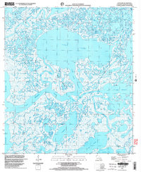
1998 Map of Lost Lake
USGS Topo · Published 2003About this map
Lost Lake dominates this coastal Louisiana landscape, a central hub in a complex network of bayous and wetlands in Terrebonne Parish. The late twentieth-century environment is defined by its shifting aquatic borders, where Lost Lake Pass and Blue Hammock Bayou cut through low-lying marshes. Industrial activity is evident throughout the region, with numerous gas wells and a larger gas field near Fiddlers Lake, indicating the importance of energy extraction in the coastal marshes. Named features like Rice Island and The Narrows provide essential orientation in a territory where land and water frequently merge. To the south and east, large bodies of water such as Lake Mechant and Mudhole Bay signal the transition toward the open gulf, connected by vital arteries like Oyster Bayou and Buckskin Bayou.
Find a feature on this map
33 named features on this map. Tap any name to fly to it.
Don’t see what you’re looking for? This feature index may not catch every label — zoom into the map to look around manually.
Map Details
Editions of this 1998 Lost Lake Map
This is the sole edition of this map. No revisions or reprints were ever made.
Other maps of this area

1894 · Bayou De Large
USGS Topo · 1:62,500

1932 · Lake Decade
USGS Topo · 1:62,500

1935 · Lake Mechant
USGS Topo · 1:31,680

1935 · Lake Penchant
USGS Topo · 1:31,680

1935 · Oyster Bayou
USGS Topo · 1:62,500

1940 · Bayou Du Large
USGS Topo · 1:62,500

1941 · Bayou Du Large
USGS Topo · 1:62,500

1944 · Bayou Du Large
USGS Topo · 1:62,500

1945 · New Orleans
USGS Topo · 1:250,000

1949 · Grand Bayou Du Large
USGS Topo · 1:31,680