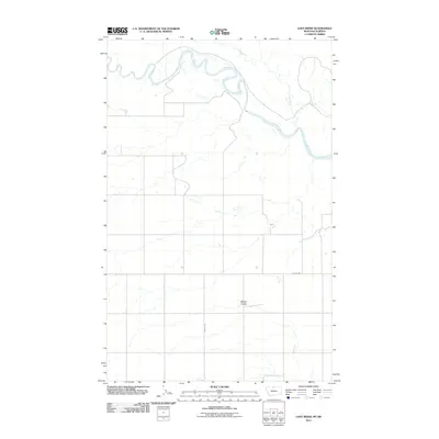
2011 Map of Lost River
USGS Topo · Published 2011About this map
The Milk River meanders through this portion of Hill County along the Montana-Alberta border, defining the northern landscape where it meets the Lost River. This 2011 survey captures a sparsely populated region of the High Plains, where the drainage of Sahara Coulee cuts through the terrain south of the river valley. The infrastructure is characterized by a precise grid of rural routes, including Hingham Rd and a primary County Hwy, which facilitate travel across the wide agricultural expanses and seasonal watercourses. The map provides a clear record of the intersection between international border geography and the essential water resources that have historically dictated land use in this northern borderland.
Find a feature on this map
5 named features on this map. Tap any name to fly to it.
Don’t see what you’re looking for? This feature index may not catch every label — zoom into the map to look around manually.
Map Details
Editions of this 2011 Lost River Map
This is the sole edition of this map. No revisions or reprints were ever made.
Other maps of this area

1919 · Alma
USGS Topo · 1:125,000

1920 · Gildford
USGS Topo · 1:125,000

1943 · Gildford
USGS Topo · 1:125,000

1954 · Shelby
USGS Topo · 1:250,000

1958 · Shelby
USGS Topo · 1:250,000
1972 · Lost River NE
USGS Topo · 1:24,000

1972 · Mc Kinnsey Reservoir East
USGS Topo · 1:24,000

1972 · Mc Kinnsey Reservoir West
USGS Topo · 1:24,000
1972 · Ninemile Coulee West
USGS Topo · 1:24,000
1972 · Lost River
USGS Topo · 1:24,000