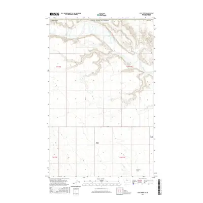
2017 Map of Lost River
USGS Topo · Published 2017About this map
The Milk River meanders through the northern reaches of this landscape near the border of Montana and Alberta, Canada. This 2017 survey by the U.S. Geological Survey reveals a section of Hill County defined by dramatic topography and deeply cut drainage patterns. The confluence of the Lost River with the Milk River forms a central geographical feature, while the surrounding high ground is dissected by various named dry washes and ravines, including the expansive Sahara Coulee in the central portion and Ninemile Coulee to the south. The sparse human footprint in this northern Montana borderland is limited to a network of section-line roads, such as RD 135 N, RD 240 N, and RD 165 N, which provide access through the sprawling prairie and rugged coulee systems like Spring Coulee.
Find a feature on this map
14 named features on this map. Tap any name to fly to it.
Don’t see what you’re looking for? This feature index may not catch every label — zoom into the map to look around manually.
Map Details
Editions of this 2017 Lost River Map
This is the sole edition of this map. No revisions or reprints were ever made.
Other maps of this area

1919 · Alma
USGS Topo · 1:125,000

1920 · Gildford
USGS Topo · 1:125,000

1943 · Gildford
USGS Topo · 1:125,000

1954 · Shelby
USGS Topo · 1:250,000

1958 · Shelby
USGS Topo · 1:250,000
1972 · Lost River NE
USGS Topo · 1:24,000

1972 · Mc Kinnsey Reservoir East
USGS Topo · 1:24,000

1972 · Mc Kinnsey Reservoir West
USGS Topo · 1:24,000
1972 · Ninemile Coulee West
USGS Topo · 1:24,000
1972 · Lost River
USGS Topo · 1:24,000