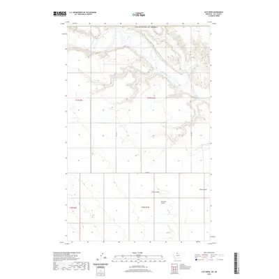
2020 Map of Lost River
USGS Topo · Published 2020About this map
Milk River and Lost River dominate this northern landscape, carving deep, winding paths across Hill County. The convergence of these waterways creates a complex drainage system characterized by several named geological features, including the broad depressions of Sahara Coulee and Ninemile Coulee. This 2020 survey illustrates the remote character of the region, where human infrastructure is limited to a sparse grid of rural routes such as RD 240 N and RD 135 N. The terrain is defined by the sharp contrast between the flat high plains and the eroded river valleys, providing a clear record of the Public Land Survey System boundaries through township and range markers like t37n r10e. Landowners and researchers can use this map to trace the exact intersection of local coulees and watercourses, such as Spring Coulee in the east.
Find a feature on this map
13 named features on this map. Tap any name to fly to it.
Don’t see what you’re looking for? This feature index may not catch every label — zoom into the map to look around manually.
Map Details
Editions of this 2020 Lost River Map
This is the sole edition of this map. No revisions or reprints were ever made.
Other maps of this area

1919 · Alma
USGS Topo · 1:125,000

1920 · Gildford
USGS Topo · 1:125,000

1943 · Gildford
USGS Topo · 1:125,000

1954 · Shelby
USGS Topo · 1:250,000

1958 · Shelby
USGS Topo · 1:250,000
1972 · Lost River NE
USGS Topo · 1:24,000

1972 · Mc Kinnsey Reservoir East
USGS Topo · 1:24,000

1972 · Mc Kinnsey Reservoir West
USGS Topo · 1:24,000
1972 · Ninemile Coulee West
USGS Topo · 1:24,000
1972 · Lost River
USGS Topo · 1:24,000