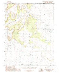
1988 Map of Lost Spring Mountain East
USGS Topo · Published 1988About this map
Lost Spring Mountain dominates the western half of this Mohave County landscape, rising sharply above the desert floor along the Arizona-Utah border. The eastern flats are marked by the presence of the Colorado City Municipal Airport and a series of ephemeral water features including several areas labeled as Lakes and Dry Lake. This late-1980s data reflects a high-desert environment where water is a critical and infrequent resource, as evidenced by the namesake Lost Spring and Wells Spring. The northern reaches are dissected by drainage systems like Short Creek and Corral Canyon, while the southern expanse is defined by broad alluvial features such as Coltonwood Wash and Sandridge Wash. Evidence of small-scale exploration or resource extraction appears in the form of scattered Prospects and a Gravel Pit near the airport.
Find a feature on this map
20 named features on this map. Tap any name to fly to it.
Don’t see what you’re looking for? This feature index may not catch every label — zoom into the map to look around manually.
Map Details
Editions of this 1988 Lost Spring Mountain East Map
This is the sole edition of this map. No revisions or reprints were ever made.
Other maps of this area

1885 · St. George
USGS Topo · 1:250,000

1886 · Kanab
USGS Topo · 1:250,000

1886 · Mt. Trumbull
USGS Topo · 1:250,000

1886 · Kaibab
USGS Topo · 1:250,000

1891 · St. George
USGS Topo · 1:250,000

1892 · Mt. Trumbull
USGS Topo · 1:250,000

1953 · Cedar City
USGS Topo · 1:250,000

1953 · Grand Canyon
USGS Topo · 1:250,000

1954 · La Verkin 4 SE
USGS Topo · 1:24,000

1954 · La Verkin 4 SW
USGS Topo · 1:24,000