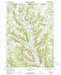
1968 Map of Lottsville
USGS Topo · Published 1989About this map
Little Brokenstraw Creek anchors the valley landscape of northern Warren County in the late 1960s, winding south from the New York state line toward the settlements of Lottsville and Wrightsville. The local economy and transport network are defined by the Erie-Lackawanna railroad, which skirts the Benson Swamp and the village of Bear Lake. This survey illustrates the rural character of the Freehold and Pittsfield townships, where family history is etched into the landscape at Bear Lake Cem and Turnpike Cem. Large tracts of the southwestern quadrant are dedicated to State Game Lands No 143, while prominent geological formations like Brooks Rocks and Pikes Rocks rise above the stream runs. The presence of a Pipeline and scattered Gas Wells suggests the ongoing energy extraction common to this region of Pennsylvania.
Find a feature on this map
34 named features on this map. Tap any name to fly to it.
Don’t see what you’re looking for? This feature index may not catch every label — zoom into the map to look around manually.
Map Details
Editions of this 1968 Lottsville Map
Other maps of this area

1904 · Chautaqua
USGS Topo · 1:62,500

1905 · Clymer
USGS Topo · 1:62,500

1926 · Youngsville
USGS Topo · 1:62,500

1929 · Corry
USGS Topo · 1:48,000

1929 · Youngsville
USGS Topo · 1:62,500

1932 · Corry
USGS Topo · 1:62,500

1939 · Clymer
USGS Topo · 1:62,500

1941 · Chautauqua
USGS Topo · 1:62,500

1941 · Clymer
USGS Topo · 1:62,500

1943 · Youngsville
USGS Topo · 1:62,500