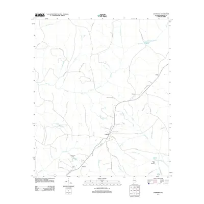
2011 Map of Louisville
USGS Topo · Published 2011About this map
Louisville serves as the central hub of this Barbour County landscape, situated at the convergence of several rural routes including HWY 130 and Railroad St. The town's organization is anchored by the Louisville Post Office, while the surrounding countryside is defined by a dense network of family-named roads and water bodies that speak to the area's agricultural and milling history. To the south, Baxters and the Mount Zion Cemetery provide key points for genealogical research near the banks of Sand Creek. The geography is notably shaped by the headwaters and tributaries of Pea Creek, with various impoundments like Robertson Millpond, Weston Lake, and Haglers Millpond illustrating how the local drainage has been managed for community use. Smaller settlements like Hobdy and Pratts appear along the northeastern routes, connected by thoroughfares such as Bethlehem Church Rd and Pittman Rd.
Find a feature on this map
64 named features on this map. Tap any name to fly to it.
Don’t see what you’re looking for? This feature index may not catch every label — zoom into the map to look around manually.
Map Details
Editions of this 2011 Louisville Map
This is the sole edition of this map. No revisions or reprints were ever made.
Other maps of this area

1953 · Dothan
USGS Topo · 1:250,000

1954 · Dothan
USGS Topo · 1:250,000

1955 · Dothan
USGS Topo · 1:250,000

1967 · Clayton South
USGS Topo · 1:24,000

1968 · Clayton North
USGS Topo · 1:24,000

1968 · Perote
USGS Topo · 1:24,000

1968 · Louisville
USGS Topo · 1:24,000
1968 · Josie
USGS Topo · 1:24,000

1968 · Mount Andrew
USGS Topo · 1:24,000
1969 · Elamville
USGS Topo · 1:24,000