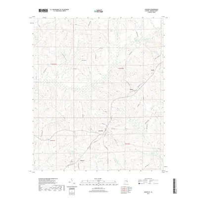
2018 Map of Louisville
USGS Topo · Published 2018About this map
Louisville serves as the central hub of this Barbour County landscape, where the street grid of Eufaula Ave and N Main St transitions into a network of rural roads defined by agricultural and milling history. The topography is deeply carved by water, with the Pea Cr drainage system and its many tributaries, including Hurricane Cr and Stinking Cr, shaping the local land use. Remnants of an earlier water-powered economy are evident in the naming of features such as Robertson Millpond, Haglers Millpond, and Carpenter Mill Cr. Smaller settlements like Pratts, Hobdy, and Baxters anchor the surrounding countryside, while the Mount Zion Cem provides a point of interest for those tracing family history in the area near Weston Lake.
Find a feature on this map
61 named features on this map. Tap any name to fly to it.
Don’t see what you’re looking for? This feature index may not catch every label — zoom into the map to look around manually.
Map Details
Editions of this 2018 Louisville Map
This is the sole edition of this map. No revisions or reprints were ever made.
Other maps of this area

1953 · Dothan
USGS Topo · 1:250,000

1954 · Dothan
USGS Topo · 1:250,000

1955 · Dothan
USGS Topo · 1:250,000

1967 · Clayton South
USGS Topo · 1:24,000

1968 · Clayton North
USGS Topo · 1:24,000

1968 · Perote
USGS Topo · 1:24,000

1968 · Louisville
USGS Topo · 1:24,000
1968 · Josie
USGS Topo · 1:24,000

1968 · Mount Andrew
USGS Topo · 1:24,000
1969 · Elamville
USGS Topo · 1:24,000