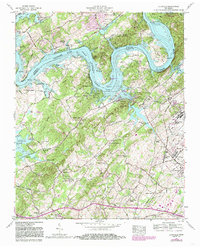
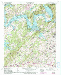
1968 Map of Louisville
USGS Topo · Published 1985About this map
The Tennessee River winds through this landscape, defining the jagged peninsula of Keller Bend and the broader waters of Fort Loudoun Lake. In the late 1960s, the community of Louisville sat as a quiet lakeside settlement, anchored by St Marks Ch and the Louisville Cem. To the south and east, the industrial presence of Alcoa and the growing footprint of the McGhee Tyson Airport reflect the regional shift toward modern aviation and manufacturing, even as local nodes like Miser Station and Middle Settlement maintain their traditional character.
Find a feature on this map
89 named features on this map. Tap any name to fly to it.
Don’t see what you’re looking for? This feature index may not catch every label — zoom into the map to look around manually.
Map Details
Editions of this 1968 Louisville Map
5 editions found
Other maps of this area

1886 · Knoxville
USGS Topo · 1:125,000

1892 · Knoxville
USGS Topo · 1:125,000

1894 · Knoxville
USGS Topo · 1:125,000

1895 · Loudon
USGS Topo · 1:125,000

1895 · Knoxville
USGS Topo · 1:125,000

1901 · Knoxville
USGS Topo · 1:125,000

1935 · Binfield
USGS Topo · 1:24,000

1935 · Knoxville
USGS Topo · 1:48,000

1935 · Meadow
USGS Topo · 1:24,000

1935 · Maryville
USGS Topo · 1:24,000