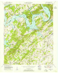
1953 Map of Louisville
USGS Topo · Published 1955About this map
The Tennessee River corridor in East Tennessee reflects a landscape undergoing modernization in the early 1950s, centered on the newly created Fort Loudoun Lake. The boundary between Knox County and Blount County follows the original river channel, winding past landmarks like Keller Bluff and Jackson Bend. On the Blount County side, the settlement of Louisville sits alongside Lackey Creek, showing a mix of established residential patterns and newer infrastructure like the nearby McGhee Tyson Air Force Base and the Sewage disposal plant.
Find a feature on this map
67 named features on this map. Tap any name to fly to it.
Don’t see what you’re looking for? This feature index may not catch every label — zoom into the map to look around manually.
Map Details
Editions of this 1953 Louisville Map
This is the sole edition of this map. No revisions or reprints were ever made.
Other maps of this area

1886 · Knoxville
USGS Topo · 1:125,000

1892 · Knoxville
USGS Topo · 1:125,000

1894 · Knoxville
USGS Topo · 1:125,000

1895 · Loudon
USGS Topo · 1:125,000

1895 · Knoxville
USGS Topo · 1:125,000

1901 · Knoxville
USGS Topo · 1:125,000

1935 · Binfield
USGS Topo · 1:24,000

1935 · Knoxville
USGS Topo · 1:48,000

1935 · Meadow
USGS Topo · 1:24,000

1935 · Maryville
USGS Topo · 1:24,000