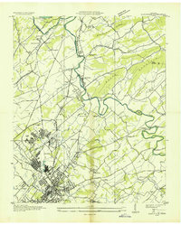
1935 Map of Maryville
USGS Topo · Published 1935About this map
Maryville and the industrial activity of Alcoa dominate this mid-1930s landscape, illustrating a period of significant development under the Tennessee Valley Authority. The map details the infrastructure of the Aluminum Company of America, including the Alcoa Water Supply, Alcoa Reservoir, and a network of power transmission lines. This industrial footprint contrasts with the surrounding rural landscape of Bays Mountain and the Tarkiln Valley.
Find a feature on this map
73 named features on this map. Tap any name to fly to it.
Don’t see what you’re looking for? This feature index may not catch every label — zoom into the map to look around manually.
Map Details
Editions of this 1935 Maryville Map
This is the sole edition of this map. No revisions or reprints were ever made.
Other maps of this area

1886 · Knoxville
USGS Topo · 1:125,000

1892 · Knoxville
USGS Topo · 1:125,000

1894 · Knoxville
USGS Topo · 1:125,000

1895 · Loudon
USGS Topo · 1:125,000

1895 · Knoxville
USGS Topo · 1:125,000

1901 · Knoxville
USGS Topo · 1:125,000

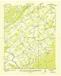
1935 · Binfield
USGS Topo · 1:24,000

1935 · Knoxville
USGS Topo · 1:48,000
1935 · Wildwood
USGS Topo · 1:24,000

1935 · Bearden
USGS Topo · 1:24,000