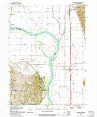
1994 Map of Loveland
USGS Topo · Published 1994About this map
The Missouri River corridor north of Omaha is defined here by a complex network of active and former channels, including the prominent Boyer Chute and the winding Boyer River. This landscape reflects decades of river management, marked by extensive levee systems and conservation areas such as the De Soto National Wildlife Refuge and Wilson Island State Park. Small settlements and locales like Loveland, Grable, and Nashville sit near the bluffs and floodplain, while an Old Railroad Grade provides a hint of the region's earlier transportation infrastructure. The topography shifts dramatically from the flat alluvial bottomlands to the bluffs where Hummel Park and the historic site of Fort Calhoun are located, illustrating the geographic boundary between the river valley and the uplands.
Find a feature on this map
26 named features on this map. Tap any name to fly to it.
Don’t see what you’re looking for? This feature index may not catch every label — zoom into the map to look around manually.
Map Details
Editions of this 1994 Loveland Map
This is the sole edition of this map. No revisions or reprints were ever made.
Other maps of this area

1893 · Omaha
USGS Topo · 1:62,500

1893 · Fremont
USGS Topo · 1:125,000

1896 · Fremont
USGS Topo · 1:125,000

1954 · Omaha
USGS Topo · 1:250,000

1955 · Fremont
USGS Topo · 1:250,000

1956 · Irvington
USGS Topo · 1:24,000

1956 · Council Bluffs North
USGS Topo · 1:24,000

1956 · Omaha North
USGS Topo · 1:24,000

1957 · Fremont
USGS Topo · 1:250,000

1957 · Omaha
USGS Topo · 1:250,000