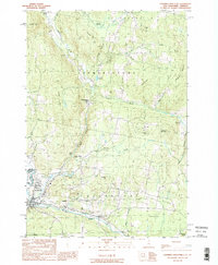
1989 Map of Lovering Mountain
USGS Topo · Published 1989About this map
Colebrook and Stewartstown Hollow anchor this survey of the New Hampshire and Vermont borderlands in the late 1980s. The landscape is defined by the winding course of the Mohawk River and its various tributaries, including the West Branch Mohawk River and Bishop Brook. The map reveals a rural economy and infrastructure integrated with the terrain, featuring a Fish Hatchery, multiple Gravel Pits, and a Golf Course on the outskirts of Colebrook.
Find a feature on this map
48 named features on this map. Tap any name to fly to it.
Don’t see what you’re looking for? This feature index may not catch every label — zoom into the map to look around manually.
Map Details
Editions of this 1989 Lovering Mountain Map
2 editions found
Other maps of this area

1925 · Indian Stream
USGS Topo · 1:48,000

1926 · Indian Stream
USGS Topo · 1:62,500

1927 · Indian Stream
USGS Topo · 1:62,500

1929 · Averill
USGS Topo · 1:62,500

1930 · Dixville
USGS Topo · 1:62,500

1933 · Dixville
USGS Topo · 1:62,500

1934 · Dixville
USGS Topo · 1:62,500

1949 · Jackman
USGS Topo · 1:250,000

1950 · Lewiston
USGS Topo · 1:250,000

1953 · Averill
USGS Topo · 1:62,500