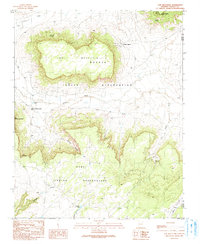
1990 Map of Low Mountain
USGS Topo · Published 1991About this map
Balakai Mesa and the high desert plateaus of Northeastern Arizona define this 1990 provisional study, marking the intersection of the Navajo Indian Reservation and the Hopi Indian Reservation. The small community of Low Mountain is situated along the Tse Chizzi Wash, where the landscape is characterized by deep erosional features like Wind Whistle Canyon and Keams Canyon. Water management is central to life in this arid environment, evidenced by named water sources such as Tse Chizzi Spring, Denezitpi Spring, and Coyote Spring, along with a network of Check Dams and Sewage Disposal Ponds. The presence of landmarks like Smoke Signal Point and Smoke Signal suggests traditional communication nodes or high-altitude lookout points. This map documents a transitional period for these tribal lands, capturing the placement of rural residences and infrastructure before the turn of the millennium.
Find a feature on this map
20 named features on this map. Tap any name to fly to it.
Don’t see what you’re looking for? This feature index may not catch every label — zoom into the map to look around manually.
Map Details
Editions of this 1990 Low Mountain Map
This is the sole edition of this map. No revisions or reprints were ever made.
Other maps of this area

1883 · Marsh Pass
USGS Topo · 1:250,000

1883 · Tusayan
USGS Topo · 1:250,000

1886 · Tusayan
USGS Topo · 1:250,000

1886 · Fort Defiance
USGS Topo · 1:250,000

1892 · Fort Defiance
USGS Topo · 1:250,000

1892 · Marsh Pass
USGS Topo · 1:250,000

1892 · Canyon De Chelly
USGS Topo · 1:250,000

1947 · Flagstaff
USGS Topo · 1:250,000

1954 · Shiprock
USGS Topo · 1:250,000

1954 · Flagstaff
USGS Topo · 1:250,000
Featured Places
- Chinle Agency, AZ
- Fort Defiance Agency
- Low Mountain, Fort Defiance Agency
- Smoke Signal, Chinle Agency
- Navajo County, AZ