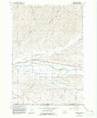
1991 Map of Lowden
USGS Topo · Published 1992About this map
The fertile floor of the Walla Walla Valley is defined here by a sophisticated network of irrigation infrastructure essential to Washington agriculture in the early 1990s. The settlement of Lowden serves as a central point along the Walla Walla River, where the landscape is intricately carved by the Garden City Canal, Burlingame Canal, and Mud District No 7 Canal. These man-made waterways, alongside the Frog Hollow Ditch and Williams Ditch, illustrate the intense water management required to transform this region into a productive agricultural hub. Cultural history is anchored by the Frenchtown Monument, marking the heritage of the valley near the Oregon state line. To the north, the terrain transitions into the steep, deeply incised drainages of Woodward Canyon and Webber Canyon, showing the geographic contrast between the irrigated lowlands and the higher, dry canyon lands.
Find a feature on this map
33 named features on this map. Tap any name to fly to it.
Don’t see what you’re looking for? This feature index may not catch every label — zoom into the map to look around manually.
Map Details
Editions of this 1991 Lowden Map
This is the sole edition of this map. No revisions or reprints were ever made.
Other maps of this area

1915 · Wallulah
USGS Topo · 1:96,000

1918 · Wallula
USGS Topo · 1:125,000

1919 · Walla Walla
USGS Topo · 1:125,000

1921 · Walla Walla
USGS Topo · 1:125,000

1935 · Pendleton
USGS Topo · 1:125,000

1953 · Pendleton
USGS Topo · 1:250,000

1953 · Walla Walla
USGS Topo · 1:250,000

1956 · Pendleton
USGS Topo · 1:250,000

1958 · Walla Walla
USGS Topo · 1:250,000

1964 · Milton-Freewater
USGS Topo · 1:24,000