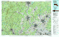
1988 Map of Lowell
USGS Topo · Published 1988About this map
The Merrimack River serves as the industrial and geographical spine of this 1980s landscape, connecting the dense urban centers of Manchester, Nashua, Lowell, and Lawrence. This metric topographic survey captures the region at a peak of late-twentieth-century development, where established textile cities are buffered by a massive network of state-managed lands. To the west, the Wapack Range and Pack Monadnock Mountain define a more rugged terrain, while the eastern reaches transition into the sprawling wetlands of the Ipswich River and Great Meadows National Wildlife Refuge. The map meticulously details the dense road networks and suburban expansion around Chelmsford Center and Londonderry, contrasting with protected natural areas like Willard Brook State Forest and Harold Parker State Forest. It provides a clear picture of the Merrimack Valley's evolution from a river-driven manufacturing corridor into a complex metropolitan belt.
Find a feature on this map
184 named features on this map. Tap any name to fly to it.
Don’t see what you’re looking for? This feature index may not catch every label — zoom into the map to look around manually.
Map Details
Editions of this 1988 Lowell Map
2 editions found
Other maps of this area

1885 · Worcester
USGS Topo · 1:62,500

1886 · Lawrence
USGS Topo · 1:62,500

1886 · Worcester
USGS Topo · 1:62,500

1886 · Lowell
USGS Topo · 1:62,500

1886 · Framingham
USGS Topo · 1:62,500

1887 · Winchendon
USGS Topo · 1:62,500

1887 · Marlboro
USGS Topo · 1:62,500

1887 · Barre
USGS Topo · 1:62,500

1887 · Fitchburg
USGS Topo · 1:62,500

1888 · Newburyport
USGS Topo · 1:62,500