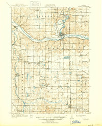
1918 Map of Lowell
USGS Topo · Published 1950About this map
The confluence of the Grand River and the Thornapple River serves as a focal point for settlement and industry in this early twentieth-century survey of Kent and Ionia counties. The town of Lowell dominates the central landscape, positioned where the Grand Trunk railroad follows the river valley. Further west, Ada marks another significant river crossing, while the surrounding townships of Vergennes and Cascade are dotted with a high density of rural schoolhouses, such as McPherson School and Snow School, which indicate the established farming communities of the era.
Find a feature on this map
90 named features on this map. Tap any name to fly to it.
Don’t see what you’re looking for? This feature index may not catch every label — zoom into the map to look around manually.
Map Details
Editions of this 1918 Lowell Map
4 editions found
Other maps of this area

1914 · Grand Rapids
USGS Topo · 1:62,500

1916 · Ionia
USGS Topo · 1:62,500

1918 · Cedar Springs
USGS Topo · 1:62,500

1918 · Ionia
USGS Topo · 1:62,500

1918 · Lowell
USGS Topo · 1:62,500

1943 · Cedar Springs
USGS Topo · 1:62,500

1943 · Grand Rapids
USGS Topo · 1:62,500

1943 · Ionia
USGS Topo · 1:62,500

1943 · Lowell
USGS Topo · 1:62,500

1950 · Nashville
USGS Topo · 1:62,500
Featured Places
- Cascade Charter Township, MI
- Ada Township, MI
- Lowell Charter Township, MI
- Vergennes Township, MI
- Lowell, MI