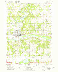
1978 Map of Lowell
USGS Topo · Published 1979About this map
The confluence of the Flat River and the Grand River centers this late-1970s view of Kent and Ionia Counties. The settlement of Lowell thrives at this junction, served by the Grand Trunk Western and Chesapeake and Ohio railroads. To the north, the historic cluster of Fallassburg is situated near Fallassburg County Park and the Fallass Cem, marking an area with deep roots in the regional landscape. The geography is further defined by extensive conservation and recreation tracts, including the Lowell State Game Area. Small rural landmarks such as the Honey Creek Childrens Home, St Marys Ch, and family-named cemeteries like McBride Cem and Pinkney Cem are scattered across the townships of Vergennes, Lowell, and Boston, providing valuable data for those researching local lineage and land use during this period.
Find a feature on this map
48 named features on this map. Tap any name to fly to it.
Don’t see what you’re looking for? This feature index may not catch every label — zoom into the map to look around manually.
Map Details
Editions of this 1978 Lowell Map
This is the sole edition of this map. No revisions or reprints were ever made.
Other maps of this area

1916 · Ionia
USGS Topo · 1:62,500

1918 · Ionia
USGS Topo · 1:62,500

1918 · Lowell
USGS Topo · 1:62,500

1943 · Ionia
USGS Topo · 1:62,500

1943 · Lowell
USGS Topo · 1:62,500

1954 · Midland
USGS Topo · 1:250,000

1958 · Midland
USGS Topo · 1:250,000

1958 · Grand Rapids
USGS Topo · 1:250,000

1959 · Midland
USGS Topo · 1:250,000

1961 · Grand Rapids
USGS Topo · 1:250,000
Featured Places
- Lowell Charter Township, MI
- Vergennes Township, MI
- Lowell, MI
- Keene Township, MI
- Fox's Mill, Vergennes Township