1969 Map of Lowell
USGS Topo · Published 1988About this map
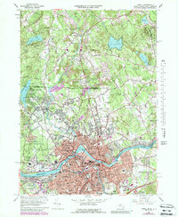
The Merrimack River dominates this mid-century landscape, carving through industrial and educational centers at the height of their post-war expansion. This survey highlights the dense institutional fabric of Lowell, noting landmarks like the Lowell Technological Institute and State Teachers College, alongside numerous parish schools including St Josephs Sch and St Michaels Sch. To the north, the terrain transitions into the more open spaces of Dracut and Pelham, where family-named features like Varnumtown and Gumpas Cem reveal the area’s deeper genealogical roots.
Find a feature on this map
112 named features on this map. Tap any name to fly to it.
Don’t see what you’re looking for? This feature index may not catch every label — zoom into the map to look around manually.
Map Details
Editions of this 1969 Lowell Map
This is the sole edition of this map. No revisions or reprints were ever made.
Other maps of this area

1886 · Lawrence
USGS Topo · 1:62,500

1886 · Lowell
USGS Topo · 1:62,500

1888 · Haverhill
USGS Topo · 1:62,500

1888 · Lawrence
USGS Topo · 1:62,500

1890 · Haverhill
USGS Topo · 1:62,500

1893 · Lowell
USGS Topo · 1:62,500

1893 · Lawrence
USGS Topo · 1:62,500

1893 · Haverhill
USGS Topo · 1:62,500

1905 · Manchester
USGS Topo · 1:62,500

1918 · Lowell
USGS Topo · 1:62,500