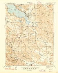
1945 Map of Lower Lake
USGS Topo · Published 1947About this map
The southern shores of Clear Lake and the geothermal activity of the Coast Ranges dominate this 1943 survey. The landscape is dotted with resort settlements and mineral spas that defined the era's local economy, including Seigler Mtn Springs, Harbin Springs, and Ettawa Springs. These sites, along with Hobergs and Adams, illustrate a transition from pioneer ranching to a specialized recreation industry centered on the region's volcanic geology.
Find a feature on this map
119 named features on this map. Tap any name to fly to it.
Don’t see what you’re looking for? This feature index may not catch every label — zoom into the map to look around manually.
Map Details
Editions of this 1945 Lower Lake Map
2 editions found

Other maps of this area

1920 · Venado
USGS Topo · 1:62,500

1920 · Healdsburg
USGS Topo · 1:62,500

1921 · Kelseyville
USGS Topo · 1:62,500

1924 · Bartlett Springs
USGS Topo · 1:62,500

1927 · Calistoga
USGS Topo · 1:62,500

1933 · Healdsburg
USGS Topo · 1:48,000

1938 · Lakeport
USGS Topo · 1:62,500

1940 · Healdsburg
USGS Topo · 1:62,500

1942 · Bartlett Springs
USGS Topo · 1:62,500

1942 · St. Helena
USGS Topo · 1:62,500