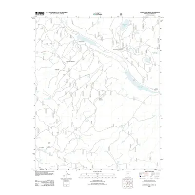
2011 Map of Lower Lake Mary
USGS Topo · Published 2011About this map
Lower Lake Mary and its associated meadows dominate this high-altitude landscape south of Flagstaff. The map documents an intricate network of forest service roads and fire routes, such as Fire Rd 296 and Hoxworth Springs Rd, that provide access to various watering points essential for local livestock or wildlife, including Mustang Park Tank and Hey Dog Tank. The presence of the United States Geological Survey Observatory near Walnut Creek highlights the area's scientific utility, while Lake View Forest Camp and Coulter Cabin indicate long-standing recreational and seasonal habitation. This survey reflects the modern management of the Coconino National Forest, where natural features like Hoxworth Springs and Thomas Spring are integrated into a system of named draws and meadows like Lake Mary Meadows and Elk Park Meadows, preserving the identity of specific locales within the pine-forested terrain.
Find a feature on this map
70 named features on this map. Tap any name to fly to it.
Don’t see what you’re looking for? This feature index may not catch every label — zoom into the map to look around manually.
Map Details
Editions of this 2011 Lower Lake Mary Map
This is the sole edition of this map. No revisions or reprints were ever made.
Other maps of this area

1886 · San Francisco Mtns
USGS Topo · 1:250,000

1887 · Verde
USGS Topo · 1:250,000

1891 · San Francisco Mtns
USGS Topo · 1:250,000

1892 · Verde
USGS Topo · 1:250,000

1894 · San Francisco Mtns
USGS Topo · 1:250,000

1899 · San Francisco Mtns
USGS Topo · 1:250,000

1908 · Flagstaff
USGS Topo · 1:125,000

1912 · Flagstaff
USGS Topo · 1:125,000

1923 · Camp Verde
USGS Topo · 1:125,000

1932 · Camp Verde
USGS Topo · 1:125,000