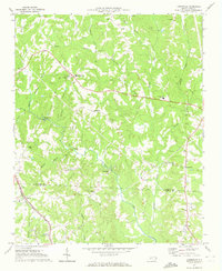
1970 Map of Lowesville
USGS Topo · Published 1972About this map
Lowesville and the surrounding Piedmont landscape of Lincoln and Gaston Counties appear here during a period of steady rural development in 1970. The area is defined by a dense network of country churches and family burial grounds, including the Tuckers Grove Ch Cem and the nearby Tuckers Grove Campground, which serve as significant cultural anchors for the local community. The terrain is deeply etched by a series of south-flowing waterways, most notably Leepers Creek and Killian Creek, which dictate the placement of early crossings such as McDowell Bridge and McClure Bridge.
Find a feature on this map
46 named features on this map. Tap any name to fly to it.
Don’t see what you’re looking for? This feature index may not catch every label — zoom into the map to look around manually.
Map Details
Editions of this 1970 Lowesville Map
This is the sole edition of this map. No revisions or reprints were ever made.
Other maps of this area

1893 · Statesville
USGS Topo · 1:125,000

1895 · Hickory
USGS Topo · 1:125,000

1914 · Gastonia
USGS Topo · 1:48,000

1916 · Gastonia
USGS Topo · 1:62,500

1941 · Charlotte
USGS Topo · 1:125,000

1942 · Charlotte
USGS Topo · 1:125,000

1948 · Paw Creek
USGS Topo · 1:24,000

1949 · Hicks Crossroads
USGS Topo · 1:24,000

1953 · Charlotte
USGS Topo · 1:250,000

1954 · Charlotte
USGS Topo · 1:250,000