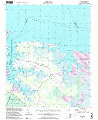
2000 Map of Lowland
USGS Topo · Published 2001About this map
Goose Creek Island dominates this coastal landscape, defined by a labyrinth of marshes and tidal guts where the Pamlico River meets the sound. At the turn of the millennium, the community of Lowland serves as the central hub of this low-lying territory, connected by the main road to outlying points like Warden Grove and Caraway Landing. The geography is dictated by water, with the Intracoastal Waterway cutting a straight path through the western marshes, contrasting with the sinuous natural reaches of Goose Creek and Oyster Creek.
Find a feature on this map
83 named features on this map. Tap any name to fly to it.
Don’t see what you’re looking for? This feature index may not catch every label — zoom into the map to look around manually.
Map Details
Editions of this 2000 Lowland Map
This is the sole edition of this map. No revisions or reprints were ever made.
Other maps of this area

1950 · Vandemere
USGS Topo · 1:24,000

1950 · Lowland
USGS Topo · 1:24,000

1950 · South Creek
USGS Topo · 1:24,000

1950 · Jones Bay
USGS Topo · 1:24,000

1951 · Brant Island
USGS Topo · 1:24,000

1951 · Pamlico Point
USGS Topo · 1:24,000

1951 · Ransomville
USGS Topo · 1:24,000

1951 · Pamlico Beach
USGS Topo · 1:24,000

1951 · Scranton
USGS Topo · 1:24,000

1953 · Rocky Mount
USGS Topo · 1:250,000